Tapovan, Rishikesh to Badrinath – 291 km
……………………………………………………………………………………………………………………………………………………………………………..
Laxman Jhula, Rishikesh to Chamba – 61 km approx.
Laxman Jhula > Bhadra Kali temple (5 km) > Bagardhar (18 km) > Hindolakhal (2 km) > Agrakhal (4 km) > Bemuda Fall (14 km) > Nagni (9 km) > Chamba Chowk (9 km)
( follow National Highway 94)
……………………………………………………………………………………………………………………………………………………………………………..
Laxman Jhula, Rishikesh to Chandrabadni Devi – 99 km approx. +1 km walk
Laxman Jhula, Rishikesh > Neergarh Waterfall (3.5 km) > Osho Gangadham, Brahm Puri (1 km) > Vashisht Gufa, Gular (14.5 km) > Devprayag (47 km) > Devprayag Tehsil left-turn (2 km)
(From Laxman Jhula follow National Highway 58 to reach Devprayag Tehsil. Turn left for Chandrabadni devi) > Hindolakhal (17 km) > Jamnikhal (7 km) > Jhald Village (2 km) > Chandrabadni Devi, Jurana Village (5 km)
(once you reach Chandrabadni devi you have to walk a further 1 km to reach the temple)
……………………………………………………………………………………………………………………………………………………………………………..
Laxman Jhula, Rishikesh to Devprayag – 66 km approx.
Devprayag to Chandrabadni Devi – 33 km approx.
I started the journey at 8:50 morning hours solo by Royal Enfield Thunderbird Twinspark motorbike from Laxman Jhula, Rishikesh reached Devprayag at 10:50 morning hours. And for Chandrabadni Devi temple I hire a jeep at 12 afternoon hours from Devprayag Tehsil and was back at the same spot i.e., Devprayag Tehsil at 5:00 evening hours.
Laxman Jhula, Rishikesh to Devprayag Total Travel Time: 2 hours approx.
Devprayag Tehsil to Chandrabadni Devi temple (to-and-fro) Total Travel Time: 5 hours approx.
……………………………………………………………………………………………………………………………………………………………………………..
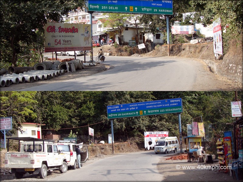
Tapovan, Rishikesh to Delhi – 251 km
Rishikesh to Mohan Nagar Chowk, Ghaziabad, Uttar Pradesh – 224 km approx.
Rishikesh > Gurukul Kangdi University, Haridwar (32.5 km) > Kali Mandir Chowk turn left (9 km) > Patanjali Yogpeeth (4.5 km) > Roorkee (11 km) > Manglaur (10 km) > Rampur (38 km) > Vehalna Bypass/Railway crossing/Rana Chowk/Rana Bypass turn left (16 km) > Khatauli (16 km) > Modipuram Bypass turn right (28.5) > Modinagar (25.5) > Mohan Nagar Chowk, Ghaziabad, Uttar Pradesh (33 km) (Mohan Nagar Chowk turn left towards Delhi)
(follow National Highway 58 from Rishikesh to reach Delhi)
……………………………………………………………………………………………………………………………………………………………………………..
Tapovan, Rishikesh to Haridwar – 29 km approx.
……………………………………………………………………………………………………………………………………………………………………………..
Rishikesh to Kasol – 488 km approx.
I was never been to Kasol by motorbike though years back I pass through the same to visit Manikaran I this time decided to take a friend’s advice who had done many road tours on a motorbike and the friendly guidance as follows:
Rishikesh > Dehradun > Paonta Sahib > Kala Amb > Narayangarh > Raipur Rani > Panchkula > Pinjore > Baddi > Nalagarh > Swarghat > Bilaspur > Sundernagar > Mandi > Bhuntar > Kasol
I also started searching the internet to have a glimpse of the road route and a phone call from the same friend to join as he and a few of his friends were leaving for Kasol by Royal Enfield motorbikes. 350 CC – Standard, Electra models, and I with Thunderbird Twinspark. Six bikers, early morning hours, and the thumping sound. People on the street, highway, and fields watch us amazingly as we pass one by one.
We started the journey at 6 morning hours.
Rishikesh > Dehradun (43 km) > Paonta Sahib (49 km) > Markandey Bridge (38 km) > Kala Amb (17 km) > Pinjore (62 km) > Kalka (8 km) > Baddi (21 km) > Solan (17 km) > Swarghat (33 km) > Buntar (169 km) > Kasol (31 km)
Had heavy breakfast at a dhaba close to Markandy Bridge and reached Kasol at 9:30 night. Fifteen hours and thirty minutes total traveling time. We all were tired and rest was required urgently. Most of us selected Kasol as a resting destination though the wish was to stay somewhere between Kasol and Manikarn.
Anyways, Kasol is beautiful. Thick pine forests all around Parvati Valley and Parvati River flow with full current. Cool – The atmosphere but they say if you move further 30 km approx., you will reach ‘Kheer Ganga’ at the height of 10,500 feet, and it is almost heaven. As the days were rainy though having the wish to visit nearby villages as well as ‘Kheer-Ganga’ I dropped the idea of trekking because it may be risky. I thought of visiting Manikarn.
Manikarn height is approx. 6,000 feet from sea level and situated on the right side of the Parvati River. 30 plus km from Bhunter and approx. 3 km from Kasol also known for Gurudwara as well as Naina Bhagwati temple.
History says Lord Shiva and Goddess Parvati once came here and meditated for more than 11,000 years. It is believed once during the bath Goddess Parvati lost her ‘Chintamani‘ (Manikaran also known as Chintamani.) i.e., ear-ring. Lord Shiva ordered his disciple to search for Mani but they failed. This angered Lord Shiva and he opened his third eye. The third eye reflection, glow, and energy gave birth to Goddess Naina Bhagwati. Goddess Bhagwati informed that the precious Mani was lying with the underwater God – Shesh Nag in Patal Lok. Upon the request from various deities, Shesh Nag obliged and gave back the Mani by making a loud sniff. Due to sniff hot water springs busted out and many other jewels came out. Goddess Parvati took away her Mani and Lord Shiva became calm.
During the Mahabharatha war, Lord Shiva fought with Arjuna at Manikarn to test him and later gifted him Pashupatastra.
15 Asoo 1574 Bikrmi Shri Guru Nanak Dev ji reached Manikarn with his two disciples Bala and Mardana. Even Mardana discovered Hot springs by lifting a stone when Shri Guru Nanak Dev Ji asked him to do so. In the year 1940 Sant Baba Narain Hari ji discovered this place and constructed Gurudwara.
The above said is what I read and learn from various display boards at Manikarn during the short tour. Next time ‘Kheer Ganga’ visit for sure.
……………………………………………………………………………………………………………………………………………………………………………..
Tapovan, Rishikesh to Kedarnath – 223 km approx.
……………………………………………………………………………………………………………………………………………………………………………..
Laxman Jhula, Rishikesh to Khirsu via Srinagar – 132.5 km approx.
Recently I traveled solo by Royal Enfield Thunderbird Twinspark motorbike via National Highway 58 driving through Kaudiyala, Devprayag. It is 6 hours approx. journey as National Highway 58 road widening work is in progress.
……………………………………………………………………………………………………………………………………………………………………………..
Lansdowne to Rishikesh via Laxman Jhula – 94.5 km approx.
Lansdowne > Jahrikhal (5.5 km) > Gumkhal (7 km) (once you reach Gumkhal [ NH 119 ] take a left-turn towards Kirtikhal or ask for Bhairavgadi temple. Follow the road ) > Kirtikhal (5.5 km) (Kirtikhal – if you wish you can stop to visit Bhairavgadi temple – 40 minutes climb) > Dwarikhal (6 km) > Chailusain (8 km) > Gaindkhal (32.5 km) (Once I cross Gaindkhal road-condition was not good. The work is in progress. But the rest road-condition from Gaindkhal till Lansdowne – excellent but remembers mostly entire road route is with very less traffic but yes, there are numerous small villages) > Mohan Chatti (14.5 km) (At Mohan Chatti road construction was going on. Jumpin Heights is at Mohan Chatti. One can stop if interested for Bungy Jump) > Laxman Jhula, Rishikesh (15.5 km)
I started solo by Royal Enfield Thunderbird Twinspark motorbike at 9:30 morning hours from Lansdowne and reached Laxman Jhula, Rishikesh at 1:00 afternoon hours.
Total Travel Time from Lansdowne to Laxman Jhula, Rishikesh: 3:30 hours approx.
Note: I saved 45 km approx. and one hour time via Laxman Jhula. If you remember while going towards Lansdowne I selected the route via Kotdwar which was 140 km approx. and took 4:30 hours approx.
……………………………………………………………………………………………………………………………………………………………………………..
Rishikesh to Lansdowne via Kotdwar – 140 km approx.
Ram Jhula, Rishikesh > Koyal Ghati, left-turn (4 km) > Rajaji National Park, Chilla (24 km) (4 km approx. from Rajaji National Park there are two roads. Right-turn towards Har-Ki-Pauri, straight towards Chandi Devi. Drive straight) > Chandi Devi, Haridwar (6 km) > Kangadi Village (5.5 km) > Kotdwar (58.5 km) (16 km approx. drive from Kangadi Village and a left turn (opposite the police check-post) for Laldhang. One can take the turn for Laldhang to reach Kotdwar but remember 10 approx. km drive is almost silent – I avoid the route. Drive straight about 4.5 km approx. and another left turn towards the canal to reach Kotdwar. 19.5 km approx. drive close to the canal till I cross a railway line and a left turn towards Kotdwar. A board display left-turn for Kotdwar – 21 km and a right-turn for Najibabad – 4km. I am at National Highway 119) > Durga temple (15 km) (Once you cross Kotdwar town hill road starts. On the left-hand side is Goddess Durga temple) > Lansdowne (27 km)
(5.5 km approx. driving from Durga temple a left turn towards Pauri. Right-turn for Lansdowne. Follow right-turn to reach Lansdowne)
I started solo by Royal Enfield Thunderbird Twinspark motorbike at 10 morning hours from Ram Jhula, Rishikesh reached Lansdowne at 2:30 afternoon hours. Yes, I drive slow on an average of 40kmph
Total Travel Time from Ram Jhula, Rishikesh to Lansdowne via Kotdwar: 4:30 hours approx.
……………………………………………………………………………………………………………………………………………………………………………..
Rishikesh to Manikaran – 491 km approx.
……………………………………………………………………………………………………………………………………………………………………………..
Mussoorie to Laxman Jhula, Rishikesh – 100 km approx.
Mussoorie > Mussoorie Jheel (5 km) > Bhatta Gaon (3 km) > Kuthal Gate turn right (12 km) > Malsi Deer Park (3 km) > Kishanpur Chowk (2 km) > Sarve Chowk (6 km) > Dharampur Chowk turn left (3 km) > Nehru colony turn right (1 km) > Doiwala (16 km) > Laxman Jhula (49 km)
……………………………………………………………………………………………………………………………………………………………………………..
Nainital to Rishikesh – 275 km approx.
Nainital > Kaladhungi > Ramnagar > Kashipur > Jaspur > Afzalgarh(NH 74) > Dhampur(NH 74) > Najibabad(NH 74) > Chandi Mandir, Haridwar > Rishikesh
Total Travel Time from Nainital to Rishikesh: Six Hours approx.
……………………………………………………………………………………………………………………………………………………………………………..
Rudraprayag to Laxman Jhula, Rishikesh – 139.5 km approx.
Rudraprayag > Srikot (31 km) > Devprayag (41 km) > Neer Waterfall (64 km) > Laxman Jhula, Rishikesh (3.5 km)
……………………………………………………………………………………………………………………………………………………………………………..
Rishikesh to Yamunotri – 245 km approx.
Rishikesh > Bhadra Kali Temple (5 km) > Hindolakhal (20 km) > Bemuda Fall (18 km) > Nagni (9 km) > Chamba Chowk (9 km) > Uttarkashi bypass turn left (Uttarkashi bypass is approx. 100 meters from Chamba Chowk) > Dharkot (9 km) > Kandikhal (Dabri) (13 km) > Kandisaur (Cham) (35 km) > Chinyalisaur (14 km) > Dharasu Band turn left (13 km) > Brahmakhal (14 km) > ShivGufa (7 km) > Barkot Band turn right (34 km) > Ranachatti (33 km) > Hanumanchatti (3 km) > Jankichatti (9 km) > Yamunotri temple (6 km trek)
(from Rishikesh follow National Highway 94 to reach Yamunotri)
……………………………………………………………………………………………………………………………………………………………………………..
Yamunotri to Laxman Jhula, Rishikesh via Vikasnagar – 261 km approx.
Yamunotri > Syanachatti (16 km) > Ojnaur (3 km) > Naagaon (36 km) > Kuan (12 km) > Barnigard More Bridge turn right (2 km) > Nainbagh (30 km) > Vikasnagar/Mussoorie Band turn right (13 km) > Jamuna Bridge (1 km) > Osho Ashram (22 km) > Harbatpur chowk turn left (22 km) > Dehradun (32 km) > Doiwala (23 km) > Laxman Jhula, Rishikesh (49 km)
……………………………………………………………………………………………………………………………………………………………………………..
Note: Most of the above distances and directions are as per solo travel via Royal Enfield Thunderbird Twinspark motorbike since 2010.